► This is the fifth year of archaeological campaigns in Sasamón, Olmillos de Sasamón and Villasandino.
► Archaeologists had previously documented by aerial photography and other non-invasive methods several structures surrounding the castro (hillfort) for at least 6 km, as well as several possible Roman camps.
► On-field surveys and excavations at the site have uncovered the defences built by the Romans to form this great display of military engineering, as well as the remains of Roman soldiers’ equipment.
Olmillos de Sasamón, Burgos, 13 September 2021.
The team of archaeologists led by Jesús García Sánchez (Institute of Archaeology, Mérida-CSIC) and José Manuel Costa-García (University of Salamanca) has concluded its fifth annual campaign of surveys and excavations in the region of Sasamón. This intervention, financed by the Diputación de Burgos and the town councils of Sasamón, Olmillos de Sasamón and Villasandino, has studied a series of archaeological remains documented by aerial prospecting around the Cerro de Castarreño (Olmillos de Sasamón) and which would have formed part of a Roman siege scenario.

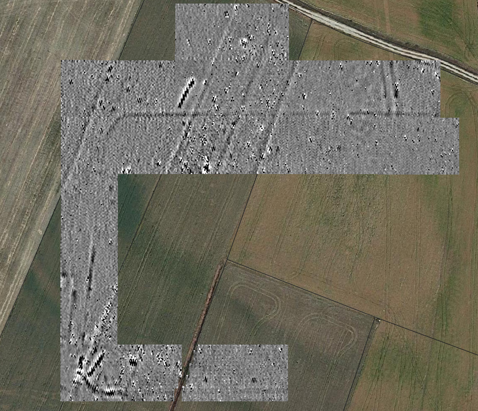
Using various remote sensing techniques, including drones, archaeologists have documented a double line of moats that, for more than 6 km, completely surrounded the castro with the aim of surrendering its occupants. At regular intervals, several camps where the invading armies would have been stationed have been identified. A second double defensive line built by the Romans has also been documented to prevent any attack from the outside while the troops were concentrating on taking the hillfort.
Although other siege sites from Roman times have been documented on the Iberian Peninsula – Numancia (Soria) and La Loma (Santibáñez de la Peña, Palencia), the closest parallel – chronologically and morphologically speaking – seems to be the siege of Alesia (France), built by Julius Caesar in the middle of the 1st century BC during his famous conquest of Gaul.

To confirm these hypotheses, during the 2021 archaeological campaign, the aforementioned structures were surveyed using geophysical methods. Geophysical surveys using GPR and magnetometer have become increasingly popular in Archaeology, as they allow three-dimensional images of the subsoil to be obtained without the need for excavation, helping archaeologists in their work to identify underground structures. To date, the members of the team have used GPR to prospect emblematic sites such as the necropolis of Pinilla Trasmonte, Roman villa complexes in Almenara de Adaja or large sectors of the Roman city of Segisamo (Sasamón), revealing its streets and buildings. The geomagnetic survey was carried out in collaboration with the Non-invasive Archaeology Laboratory (MINARQLAB) of the CSIC-IAM.
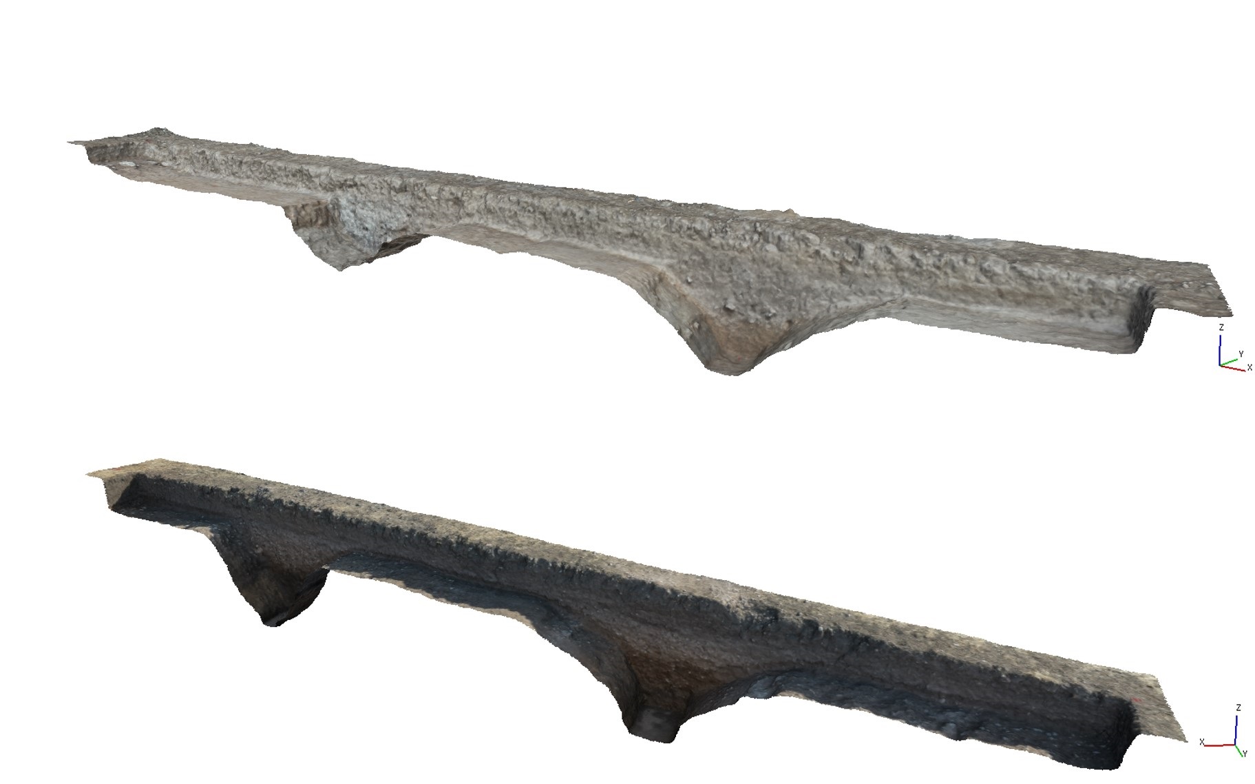
Following this, six archaeological probes were excavated in order to document first-hand the structures built by the Romans, to understand their morphology, to recover elements of relevant material culture – such as ceramics or metal tools – and to take samples for radiocarbon and thermoluminescence dating of the ancient ditches. These dating methods allow us to know quite precisely when the structures were built.
A past to be (re)discovered
Until now, only the fragmentary writings of some Greek and Latin authors were available to reconstruct the history of the conquest of these lands. From these records, we know that the Romans conquered the centre of the peninsula at the end of the 2nd century BC, but the Odra-Pisuerga region was not definitively integrated into the Roman Empire until the end of the 1st century BC. The old Iron Age settlements – such as the oppidum of Cerro Castarreño (Olmillos de Sasamón) – were abandoned in favour of other Roman settlements – such as the recently founded town of Segisamo (Sasamón). In addition, new public infrastructures appeared – roads, aqueducts, etc. – and the fields began to be exploited more intensively in order to obtain agricultural products to feed the growing population.
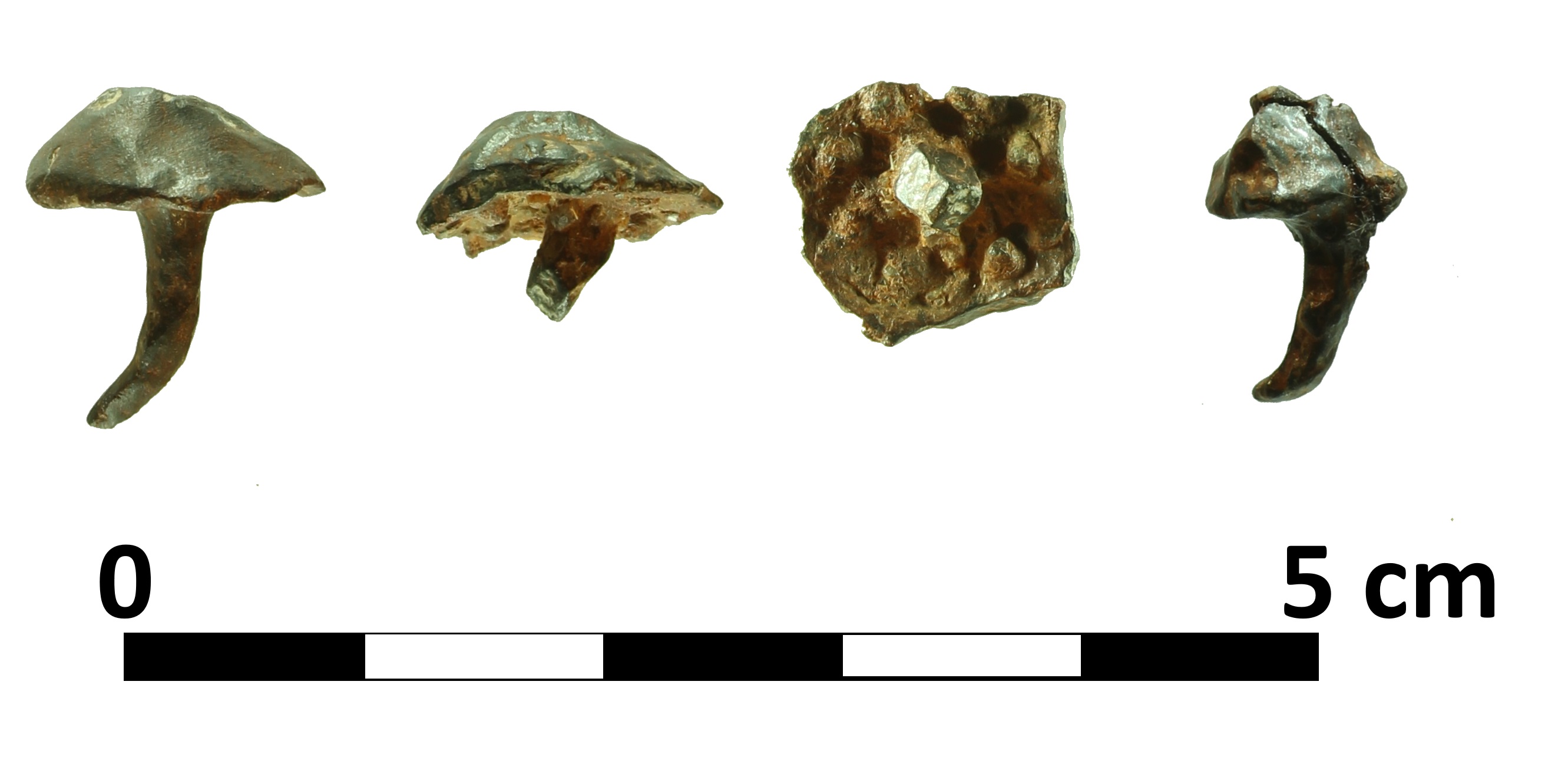
However, the work carried out by archaeologists seems to indicate that this transition process may not have been peaceful. During the 2018-2020 campaigns, several test pits were opened at Cerro de Castarreño, where it was possible to document a complete sequence of occupation of the site between the 8th century BC and the 1st century AD. In the most recent levels, dated between the 1st century BC and the 1st century AD, several pieces of Roman military equipment were documented, such as hobnails or arrowheads used by the Roman soldiers, setting off all the alarms. The presence of the army at this site was unknown until now and its mission may have been to take the castro.

The 2021 campaign confirms this point. The excavations have made it possible to verify that the alignments identified by aerial photography correspond to defensive ditches. Even with variations, they have a characteristic V-shaped section and at the bottom it is possible to document a pit with vertical walls. Metal punches or wooden stakes would have been installed here. The walls of the ditches would also have been covered with similar obstacles. Inside, an embankment topped by a palisade would have been built with earth taken from the ditches. However, it was only possible to document this structure in one of the test pits, as the ploughing had destroyed the others. In one of the test pits, an ancient well has also been excavated which may have been used by the Romans to water their troops and pack animals. Taken as a whole and well garrisoned, the documented defences would have been a formidable obstacle to any assaulting force.
During the interventions, some interesting elements of material culture have also been documented, such as ceramics dating back to the 1st century BC or the same type of hobnails recovered years ago in the Cerro. Numerous samples have also been taken to try to date the structures and the fillings of the ditches with two cutting-edge methods – radiocarbon and optically stimulated thermoluminescence- as well as to carry out pollen studies. Their results will help to better contextualise these sites and their environment in ancient times.
A consolidated project
In previous campaigns (2017 to 2020), archaeologists studied numerous sites in the Sasamón countryside. Thus, two enclaves related to the Roman army were studied (Carrecastro and Santa Eulalia), the urban area under the current town of Sasamón was surveyed and the excavation works began at the Cerro. Modern and historical aerial photographs in colour and near-infrared, satellite imagery and 3D reconstructions of the territory using LIDAR data were used for this purpose. Other sophisticated and innovative techniques have also been used, such as geophysical prospecting and the generation of maps from photographs taken by drones.
In this way, it has been possible to gain a better understanding of the Roman town planning of Segisamo – identifying the outlines of its streets and buildings -, recognise the existence of ancient Roman camps and even recover materials related to both the army and everyday life during Antiquity. Excavations on the northern spur of the Cerro de Castarreño – where the telephone aerials are currently located – made it possible to document a powerful moat dug into the moor and a slope located inside it. Numerous archaeological materials – ceramics, metals, bones – were recovered in the process.
The archaeological campaigns also serve to train future archaeologists. Students and professionals from different countries (United Kingdom, Czech Republic, Germany, Holland, Portugal, Spain, United States, Bulgaria, Italy) and institutions, as well as from different parts of Spain, have taken part or are taking part in this project.