Sites

Campamento de Moyapán desde o ONO (12/2008)
The Roman camp of Moyapán from the WNW (12/2008)

The camp of Moyapán (Ayande, Asturias) was discovered by chance in 2007, as we analysed the aerial photographs covering one of the most important Roman mining areas of western Asturias. It was the second Roman enclosure recognized in Asturias after El Picu Curriel.los (L.lena/Ayer) and it led our way on the investigation of the presence of the Roman army in Asturias and León.

Continue Reading

Publications, Sites, Techniques

This is the paper we presented at the 23th Limes Congress, held in Ingolstadt (Germany) in September 2015. There we showed the results of a research about the Roman military presence in north-western Iberia developed by us in the recent past years as well as overall review on the subject showing how the discipline has changed due to the employment of remote sensing techniques like the aerial and satellite imagery or the aerial LiDAR. This website presents a new perspective about the roman military campaigns during the conquest in augustean times of the northern territories of Cantabria and Asturias and the subsequent reorganization of the north-westernmost region of Iberia.

Even if the audio of the video is English you can change the language of the subtitles by clicking the icon of a little grind placed below near the right corner. Since this is an interactive video you can also download KMZ files with additional graphic information of every single archaeological site we talk about. You need to install Google Earth software in order to visualize these files.

At this website you can also see highlined some of the more interesting conclusions of the public paper, in which 17 new Roman military sites were presented.

Sites

A brand new vision for Roman Army in NW of Hispania

In this map you can see our proposal on the presence of the Roman army in the northwest of Hispania in 2015. Along with already investigated previously published sites, we added seventeen new locations exhibiting denser Roman military contingents presence, possible new lines progress in Asturias and the first appearances of possible marching camps in the territory of present Galicia.

Sites

A theatre of operations in the south-westerner Asturian area during the Cantabrian Wars

Our research shows a special concentration of military camps in the westernmost part of Asturias. They follow the very same settlement patterns previously detected in some other scenarios located at the Cantabrian and central-eastern Asturian regions. Although the bibliography and the ancient sources are very silent about the existence of specific war scenarios in this area, the archaeological evidences clearly show the existence of a route flanking the Asturian mountains and probably linked with the augustan campaigns or the subsequent post-war times.


Sites

A Roman Army way of entrance to the Galician territory

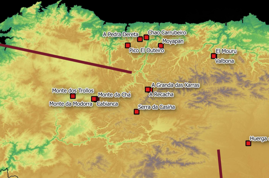
This penetration route enters Galicia from the Leonese area of O Bierzo. This fact is historiographically relevant since until now the only Roman military sites detected and excavated in Galicia were two forts (A Cidadela, Bande) belonging to later periods of the early Roman empire. Five camps can be directly linked with this military route, being placed four of them in the Galician province of Lugo and the other one in O Bierzo (León).

This last enclosure, named Serra da Casiña, is located in Valboa –close to Villafranca del Bierzo-, over a hill controlling a traditional Access way to Galicia.

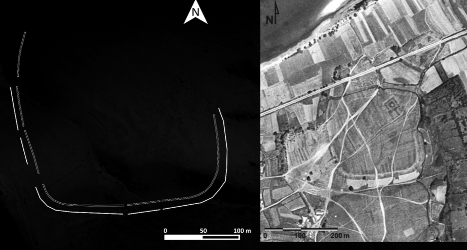
One posible logistic base at Sarria

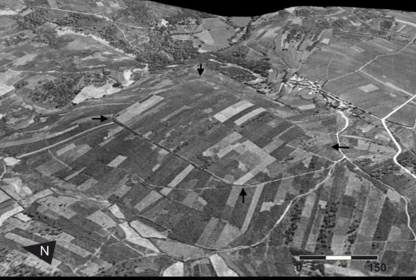
f it fulfilled its strategic, tactical or logistical needs, the Roman army could select a particular place and use it recurrently during the events of one or more military campigns. Some examples of this behaviour have been previously attested in the Península (Herramélluri –La Rioja-, Sasamón –Burgos-). A Chá de Santa Marta, between Láncara and Sarria, is an unique archaeological complex in Galicia since it comprises at least three possible Roman camps. They are located over a hill precisely at the point in which the landscape softens after we go the mountainous areas of León and Gaicia. Is it’s a reliable possibility that this place acted as a logistic axis or a regrouping point.

The three Roman camps of A Chá de Santa Marta (USAF, 1956)

Facing the crossing of the river Miño

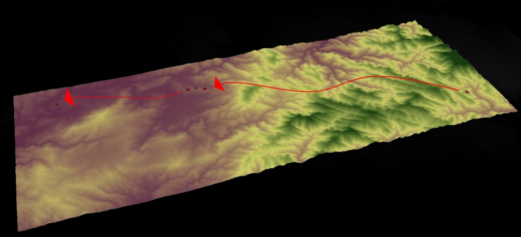
The camp of Monte dos Trollos (0 Páramo. Lugo) is placed at a very strategic position, over a hill and closet o a natural ford of the river Miño. It is only 16 km away from A Chá de Santa Marta, a distance which can be covered in just a single day of marching.

Sites

The westerner unsolved question: two camps over the Meridian Depression

Two new roman camps were located in the westernmost area of Galicia, close to the Meridian Depression, a traditional route which crosses the coastal region from south to north.

The camp of Cornado (Negreira) was presented some years ago and by now it is the most westerner Roman military camp of continental Europe.


O campamento de Cornado (Negreira) dímolo a coñecer hai uns anos. É o campamento máis occidental, ata o momento, do continente europeo.

A camp controlling the Miño

The Roman camp of Campos was identified at the Portuguese bank of the river miño, close to the town of Vilanova de Cerveira. Unfortunately it was completely destroyed some decades ago due to the construction of an industrial park.

At the present state of research, the apparent disconnection between Cornado, Campos and the other camps makes difficult to give an accurate dating or to define their precise functionality. The camps could be dated from the last stages of the late republican period to the first decades of the early empire. In any case, they are the only evidence of an early Roman military presence in the westernmost región of Galicia.